About Wingecarribee
Wingecarribee Shire is located 75 km from the south-western fringe of Sydney and 110 km from Sydney’s central business district. The Shire has a total area of approximately 2,700 km2, 56 per cent of which is north of the Wingecarribee River.
It is comparable in size to that of urban Sydney, averaging 55 km from east to west and 45 km from north to south, with its geographic centre north-west of Berrima and its demographic centre to the south-east of Bowral. Much of the Shire is located at or above 640 m above sea level.
This area is known to tourists as the Southern Highlands of New South Wales.
This Shire is an important catchment area for water supply to Sydney, Wollongong and the Northern Shoalhaven.
The main towns are:
- Bowral
- Moss Vale
- Mittagong
As well, there are smaller villages including Bundanoon, Hill Top, Yerrinbool, Colo Vale, Robertson, Berrima, New Berrima, Exeter, Burrawang, Penrose, Willow Vale, Alpine, Balaclava, Renwick, Wingello, Sutton Forest, Avoca, Fitzroy Falls, Balmoral, Medway, Wildes Meadow, Kangaloon, and East Kangaloon.
The pattern of development is one of small towns and villages, separated by a semi-rural landscape. Eastern parts of the Shire, known as the ‘Yarrawa Brush’ by early settlers, are bounded by the Illawarra Escarpment and Morton National Park.
The north of the Shire is characterised by rugged Eucalypt bushland.
This area forms part of the catchment for Sydney's water supply and three major storage dams (Avon, Nepean and Cordeaux).
The Wollondilly and Wingecarribee Rivers flow through the west of the Shire, through deep sandstone valleys and much of this area forms part of the catchment for Warragamba Dam.
The South of the Shire is bounded by Uringalla Creek and includes the villages of Bundanoon, Wingello and Penrose. This area is a sandstone plateau dissected by deep gorges.
Read about the Shire's history
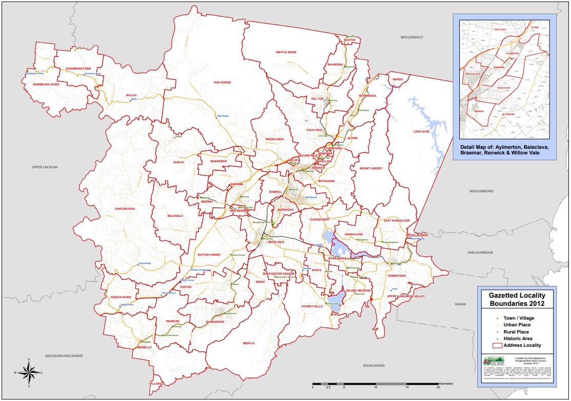
Localities, suburbs, and gazetted boundaries map of Wingecarribee Shire
- The map provided below is the authoritative map prepared with the approval of the Geographic Names Board (GNB).
- This map shows all Wingecarribee Shire's official gazetted locality names, and boundaries.
- In semi-rural areas suburbs are referred to as localities.
- It identifies our official town and village names, urban place names, rural place names and gazetted historic named areas.
- This map serves as an important and useful resource for property agents, developers, emergency services and the general public.
- The map information is current and accurate as of March 2023.
Download the Shire map(PDF, 6MB)
Official Wingecarribee Map