Gibbergunyah Reserve
A peaceful reserve in the heart of the Highlands
Gibbergunyah is a true gem which is not well known, with Aboriginal cultural heritage significance and connection to the Blue Mountains via signalling from Ninety Acre Hill Lookout.
The reserve contains an interesting mix of geology including Mittagong formation sandstone and micro syenite outcrop, as well as the headwaters of Gibbergunyah Creek.
Gibbergunyah Reserve offers visitors opportunities for beautiful scenic walks through a variety of ecological communities and is home to an array of native wildlife including echidnas, gang gang cockatoos and greater gliders.
The reserve is full of contrasts with secluded, shady walking trails and sunny, rocky outcrops to picnic on – a calm respite from the surrounding bustling town.
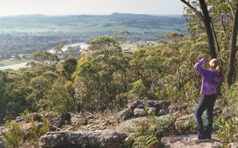
With its highest point of 814 m above sea level, Ninety Acre Hill Lookout has sweeping views of the distant Blue Mountains from its lichen clad boulders. Wombats and echidnas make their lairs in the crevices of the rocks below. There is a view of Mount Gibraltar from the Gib Lookout. Eastward its water drains into Gibbergunyah Creek and westward it looks to the Dividing Range.
The 200 ha of bushland ranges from open woodland on the drier edges to tall moist fern-carpeted forest in the deeper gullies. A variety of brightly coloured flowers bloom according to the season and tall banksia await fire to open their spiky seed-pods.
Walking trails
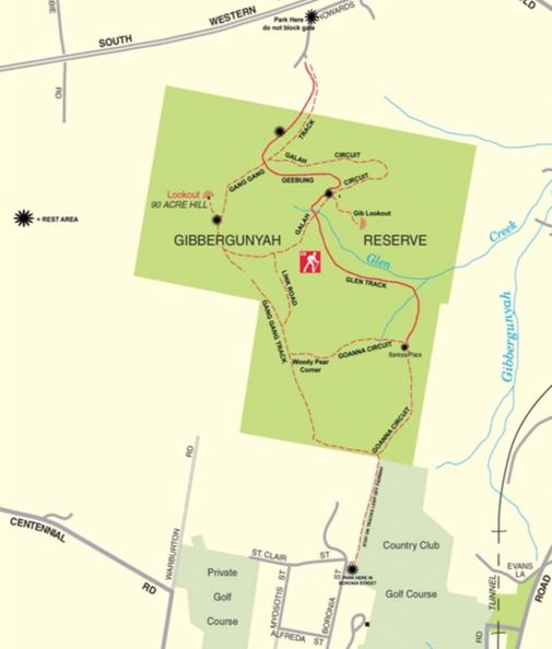 Walking trail map of Gibbergunyah.
Access to the reserve is from either Howards Lane on the Mittagong side or off a small parking area on the corner of Boronia Street and St Clair Street on the Bowral side.
The track from Howards Lane can be a bit steep and rocky, whereas access from Boronia Street skirts along the edge of the golf course and has a more gradual accent into the reserve.
There is no vehicle access to the reserve apart from Bushcare and fire management vehicles along fire trails.
The walking trails at this reserve contain both easy and steep sections, with the time required for a full circuit approximately 2.5 hours depending on the circuit walked. The ascent is up to 170 m total depending on the circuit taken.
Once on the trails you will enjoy a variety of micro climates and relative flora. From tall white barked gums to lush fern rich valleys, there is plenty to explore in the Gibbergunyah Reserve.
Conditions are mostly easy to follow fire trails, however the Geebung Track and Glen Track are unmarked bushwalking trails and not as straightforward, so extra care should be taken on those trails.
Signage is clear for all the fire trails and a small track off the Gang Gang Track leads to Ninety Acre Hill Lookout which is a great spot for a rest and lunch.
Another small track off the Galah Track takes you out to the serene Gib Lookout where a small bench offers the perfect spot for a rest.
For your own safety please always bring your own water when bushwalking. There are no facilities or amenities on these walks.
History of Gibbergunyah Reserve
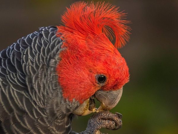 The gang gang cockatoo calls Gibbergunyah home.
“Gibbergunyah” (believed to be an amalgamation of two Aboriginal words meaning stone and house), took its name from Gibbergunyah Creek.
In earlier times the reserve was also known as the 460 Acre and as the 90 Acres.
In 1939, the area was a scene of raging bushfire which swept into Mittagong. Following that it was controlled by the Soil Conservation Service and used as a practice area by bushfire brigades.
Officially “a reserve for public recreation and the preservation of native flora and fauna” it was gazetted November 1974 by the then Council of Mittagong. Since amalgamation of the region's three local governments, reserve control and administration has passed to the Wingecarribee Shire Council.
More recently, The Gibbergunyah has become home to the annual mirror flash ceremony where the traditional owners of the land - the Gundungurra people - are celebrated, and the Wingecarribee Reconciliation Group communicates with the community in Katoomba without the aid of modern technology.
Location
Boronia Street, Bowral & Howards Lane, Welby, Bowral 2576 & 2575 View Map
-34.4661194,150.4117171
Boronia Street, Bowral & Howards Lane, Welby ,
Bowral 2576 & 2575
Boronia Street, Bowral & Howards Lane, Welby ,
Bowral 2576 & 2575
Gibbergunyah Reserve
Photo Gallery